


Ida Ismail
Floods in Albania can no longer be treated as unpredictable natural disasters. They have become a forewarned crisis, recurring almost every year in the same areas, with serious consequences and a bill that weighs heavily on citizens and the state budget. While rivers overflow their banks, agricultural lands are covered by water and hundreds of families face damage to their homes and loss of income, institutions continue to report investments, plans and preventive measures.
According to an estimate cited by the Supreme State Audit Office in its audit of floods in Albania, economic losses caused by floods during the three decades of democracy are estimated at around $2.5 billion.
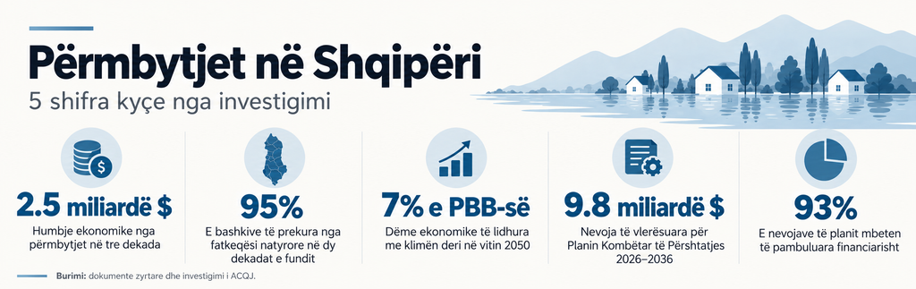
The risk extends into the coming decades. The World Bank ranks Albania among the European countries with the highest level of exposure and risk from disasters. According to it, floods, fires, landslides and earthquakes have affected 95% of municipalities over the past two decades. Meanwhile, climate-related economic damages could reach about 7% of Gross Domestic Product alone by 2050.
Shkodra, high exposure, incomplete balance sheet
The Municipality of Shkodra is one of the local units most exposed to the risk of flooding, due to its geographical position in the watershed of the Drin, Buna and Kir rivers, as well as the influence of Lake Shkodra. In its response, the municipality also mentions discharges from hydroelectric power plants as a factor influencing the situation, without providing data on their role in specific episodes.
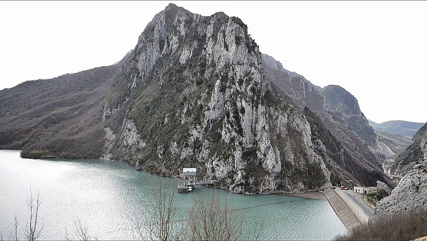
According to an analysis published by the UNDP, the Drini River’s flows could exceed the carrying capacity of the Buna River, while discharges from the Vau i Dejës hydroelectric power plant could exacerbate the situation. The risk is compounded by worn-out embankments, erosion, and construction on the surface that previously absorbed floodwaters. Climate change, with more concentrated rainfall and earlier snowmelt, is putting further pressure on this system.
The Municipality of Shkodra claims that the situation has improved significantly in recent years, although it admits that floods have continued to affect agricultural lands, mainly in the administrative units of Shkodra. As preventive measures, it lists the cleaning and maintenance of drainage channels, the strengthening and rehabilitation of embankments, as well as cooperation with local and central institutions for flood monitoring and management.
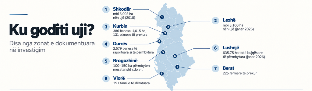
However, historical data shows a different picture. In 2018 alone, over 5.003 hectares of land were under water. Over 500 homes were surrounded by floods and 76 people were evacuated.
Lezha, between declarations of limited damage and emergency interventions
The Municipality of Lezha states that in recent years there have been no situations classified as civil emergencies and that its structures have continuously intervened to clean the drainage channels.
"During cases of intense rainfall in certain areas, temporary water presences were observed, mainly in residential yards, but without causing significant damage to homes or creating a risk to the lives of citizens," the municipality's response states.
But during the floods of January 2026 alone, over 3.100 hectares of land in the Lezha region were submerged. Dozens of families were evacuated, hundreds of homes were left isolated, and residents of Gjorm protested by blocking the Laç-Mamurras road, accusing institutions of malfunctioning drainage systems.
The AKMC also includes the Lezha region among the most affected areas during January 2026, in the description accompanying the flood map prepared based on Copernicus program data. The agency links the episode to intense rainfall and increased flows in the main rivers.
In Spiti, farmers reported three episodes of flooding within 40 days. According to residents, drainage canals are unable to cope with the amounts of water and their maintenance remains inadequate.
Kurbini, a decade of repeated damage
In Kurbin, the balance reported by the municipality for the period 2016–2026 includes 386 damaged homes, 1.015 hectares of flooded agricultural land, and 131 affected businesses. These are the total number of cases recorded over the years.
For the six years included in the municipality's table, 2016, 2017, 2019, 2021, 2025 and 2026, documented economic damages amount to around 52 million lekë. The floods of January 6-7, 2026 alone affected 102 homes, 230 hectares of agricultural land and seven businesses. For this episode, damages to equipment, furnishings and buildings were estimated at around 10,18 million lekë.
At the time of the response, the municipality announced that this amount would be passed "very soon" for decision-making by the Municipal Council and would then be given to the affected families.
For the reported period, the Kurbin Municipality states that it has provided approximately 13,96 million lek in compensation and reparations, with funding from the responsible ministries and municipal civil emergency funds. However, the document does not break down these payments by year, damage category, and beneficiaries. For this reason, the amount cannot be directly compared to the total damages to determine how much of them remained uncompensated.
The municipality argues that its investments are focused on preventing and minimizing the risk of flooding, through the local budget and funding from the Ministry of Defense. As an example, it cites the systematization and rehabilitation of two branches of the Laçi stream, interventions that, according to the institution, have significantly reduced the risk and the need for repeated expenses for compensation.
She also stated that the city of Laç has not been on the flood risk map for years. This claim refers to the city, while the damage balance covers the entire territory of the municipality. For the Mamurras Administrative Unit, the institution announces that it has applied for financing a new project for river protection on the Droje riverbed.
Matë, the lack of preventive measures is officially acknowledged
Unlike many institutions that argue that measures have been taken, the Municipality of Rrogozhina openly admits that floods continue without a preventive strategy.
"No specific preventive measures have been taken for the Shkumbin River to overflow its banks," the institution's response states, adding that floods have affected approximately the same areas for decades.
According to the municipality, an average of 100-150 hectares of agricultural land are flooded each year. For the last ten years, the institution estimates a flooded area of 1.000-1.500 hectares, as the sum of the areas affected over the years, which may include the same lands several times.
The municipality says that in recent years there have been no flooded homes and that the water in affected agricultural lands recedes within 24-48 hours. Meanwhile, about 15 businesses, mainly in Rrogozhina and Spille, have had water in their premises. However, the institution admits that it has not recorded or documented the value of economic damages for each case.
Regarding compensation, the municipality states that the affected residents have been treated according to the legal framework, referring to a fund “up to 4% of the budget”, but without providing an amount or number of beneficiaries. The wording for the funding differs from that of Article 65 of the Civil Protection Law: The law provides for a minimum of 4% of the annual budget of municipalities, provided from the conditional funds of the state budget, and allows for the planning of additional funds. This percentage covers risk reduction and civil protection in general, not just compensation.
Elbasan, reported investments and a partial balance sheet
The Municipality of Elbasan admits that several cases of flooding have been recorded in its territory over the last ten years. However, it only provides concrete data for the 2019 episode in the “5 Maji” neighborhood.
Ten family homes were damaged by that flood, with a total damage value of 1.015.500 lek. The municipality states that there is no reported data on damage to agricultural land or businesses in the mentioned cases.
Regarding prevention, the municipality says it has regulated the Camurri stream, which it identifies as the cause of the 2019 floods. According to the institution, after this intervention “the risk has been removed”. The municipality also reports the construction of 6 km of protective embankments along the Shkumbin River. For these interventions, the municipality does not provide data on the cost of investments, protected areas or the risk assessment after the completion of the works.
Durrës, thousands of flooded homes and delayed compensation
For 431 flooded apartments during January-February 2025, the Durrës municipality reports an allocated fund of about 121,43 million lek. According to the response dated February 19, 2026, about 12,28 million lek had been liquidated by that moment. On July 9, 2026, the Municipal Council approved the use of about 109,28 million lek for families that had not been financially treated or had only been partially treated after the floods of January 29-30, 2025. At the same meeting, assistance of about 10,24 million lek was also approved for the liquidation of families damaged by the floods of September and November 2025.
These decisions show that, about a year and a half after the floods of January 2025, compensation for some families had still not been completed. The approval of the funds in July, however, does not prove that payments were made subsequently.
The balance of flooded homes also needs clarification. The municipality reports a total of 2.579 homes in the response that includes episodes from the period 2018-2026. However, the data broken down by year gives 114 homes for 2018, 388 for 2020 and 431 for January-February 2025, a total of 933. For the other 1.646 homes included in the total, the document does not provide a breakdown by episode or year.
For 2018, the municipality reports about 32,95 million lek allocated and liquidated funds, while for 2020 about 47,01 million lek. In the February 2026 response, the damages from the floods of September and November 2025, as well as those of January 2026, were still in the assessment process.
Another gap relates to businesses. The municipality states that it does not have evidence of their damages during the requested periods. According to the institution's explanation, in the absence of a declaration of a state of civil emergency, damages to businesses were not taken into consideration for treatment according to the legal framework to which it refers.
Regarding preventive measures, the Municipality of Durrës says that at the beginning of each year it asks administrative units to identify problematic drainage channels. Based on this information, an annual intervention plan is drawn up, approved by the mayor, for the rehabilitation and cleaning of channels, as well as the unblocking of bridge openings from inert materials and debris. The response describes the planning procedure, but does not provide data on costs, kilometers cleaned or the implementation of works in areas that are constantly flooded.
Lushnja and the blow to agriculture
In Lushnja, the January 2026 rainfall flooded 635,75 hectares of agricultural land. Dushku was the most affected administrative unit, with 265,6 hectares under water, followed by Fier-Shegani with 128,9 hectares and Allkaj with 125,7 hectares. The floods also affected Golemi, Krutje and Karbunara.
The majority of the flooded area was planted with fodder and cereals, 245,4 and 208,4 hectares respectively. The water also covered 60,3 hectares of orchards, 37,1 hectares of olive groves, 31,4 hectares of citrus groves, 27,85 hectares of greenhouses, as well as areas with field vegetables and vineyards. In an area where agriculture is the main source of livelihood, this extent of flooding puts farmers' production and income at risk.
The municipality's table documents the affected areas and crops, but does not determine production losses or the monetary value of the damages.
Berat, agricultural damage and compensation pending
According to data from the Berat Municipality, the floods of recent years have damaged 14 homes and affected 225 farmers. The documented economic damage amounts to around 2,6 million lek for homes and 24,57 million lek for farmers.
The municipality reports compensation for the housing, while for the farmers the process was still ongoing at the time of the response dated February 26, 2026.
For prevention, the institution states that the Irrigation and Drainage sector has maintained and cleaned the canals in the territory, based on field assessments and the requests of farmers and local leaders. However, the response also identifies three damaged segments of the embankment along the Osum River. For approximately 595 meters of embankment, the municipality says that it has requested support from the Prefecture, the Ministry of Defense, the National Civil Protection Agency and the Ministry of Agriculture, initially for rapid rehabilitation and then for a more sustainable investment. The response documents the request for intervention, but does not clarify whether the works have been financed or completed.
Vlora, repeated damages and deficiencies in flood protection
In Vlora, the municipality's data for the years reported from 2016 to 2026 provide a total of 391 cases of families damaged by floods. Of these, 355 belong to 2024, the heaviest annual balance in the institution's response. For the 17 families affected in 2026, the amount of compensation was still in the process of being determined at the time of the response.
The municipality reports nearly 58 million lek in financial compensation for the years 2016, 2019, 2023 and 2024. The vast majority, around 56,46 million lek, is related to families affected in 2024. The financial total does not include in-kind assistance provided in 2017, in the form of furniture and food, nor the yet-to-be-determined compensation for 2026.
The municipality says it does not manage data on damage to agricultural lands and businesses, directing applicants to the AKMC and the Ministry of Agriculture.
For preventive measures, the municipality lists the cleaning of the high water canal, the Naunka canal and other drainage canals, as well as the cleaning, repair and maintenance of the city's hydropower plant. It also mentions planned investments in the 2026 budget for roads and canals along them, with the aim of improving drainage.
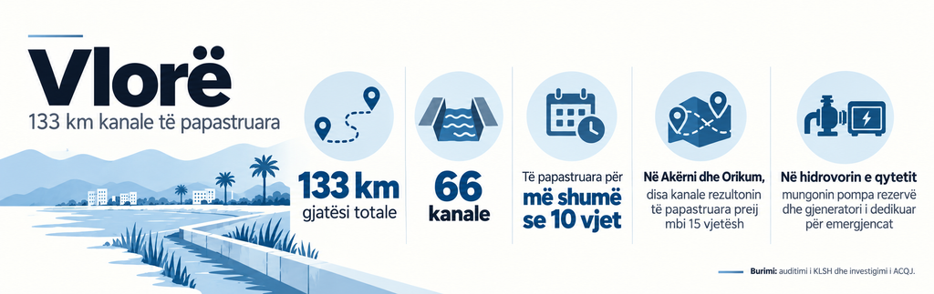
The thematic audit of the Supreme State Audit on the floods in Vlora, meanwhile, documents serious shortcomings in the maintenance of the drainage system. In six schemes administered by the Vlora sector of the Fier Irrigation and Drainage Directorate, auditors found 66 canals, with a total length of 133 kilometers, that had not been cleaned for more than ten years. Some canals in Akërni and Orikum had not been cleaned for more than 15 years. The SAI identified the lack of annual maintenance as one of the main causes of the problems of this system.
The shortcomings also extended to flood preparedness. In the city's hydropower plant, the audit found a lack of backup pumps and a generator dedicated to emergencies, as well as problems with the electricity supply. For the Vlora Region and Municipality, the auditors found no documentary evidence of the preparation and periodic approval of the risk assessment.
From mountains to drainage canals, the weaknesses of an interconnected system
Beyond damage assessments, experts link flood risk to the way the territory has been managed, from mountain slopes to river mouths. Deforestation, riverbed interventions, and inadequate infrastructure maintenance affect the path water takes and the consequences it leaves behind.
Biology professor Aleko Miho places emphasis on vegetation cover: "Heavy rainfall cannot be stopped, but it can be controlled and disciplined, without allowing it to damage our lives and property. This starts from our hills and mountains, from the preservation and renewal of vegetation cover and forests," he says.
Miho also highlights the consequences of uncontrolled urbanization and the alteration of river flows by hydropower interventions. “In degraded areas, only a small portion of precipitation infiltrates the soil, while the rest goes immediately into streams and rivers.”
Environmental expert Kristi Beshmili also raises concerns about deforestation. "We have damaged the forests, we no longer have preventive barriers because we have stripped our mountains bare," he says.
This link between rainfall and the state of the territory is also addressed in Albania's Fourth National Communication on Climate Change. For the Vjosa basin, the document notes that the years with the greatest floods coincide with extreme rainfall, but emphasizes that the consequences are also influenced by environmental degradation, maintenance of protective infrastructure and management of the basin.
Hydrologist Erjona Kalaja focuses on sediments and the changes that riverbeds undergo.
"Sedimentation is unmonitored in Albania. Floods are monitored, but there is a lack of analysis of why they happened, what worked and what didn't, and the measures that need to be taken to minimize flooding for similar flows," he says.
The Water Resources Management Agency (WRMA) did not provide a series of sediment measurements. For information on morphological changes in water bodies, the institution referred to river basin management plans. This response does not clarify where measurements are carried out, with what frequency, and how the results are used to determine interventions.
Kalaja explains that dams also change the transport of sediments: "The dam plays the role of a barrier for the transport of sediments. Practically above the dam, sediment accumulation occurs, while below it erosion increases, the banks erode and the riverbed is destabilized." According to him, aggressive exploitation of inert materials, loss of agricultural land and degradation of habitats are other signs of mismanagement of the basins.
For dams, the concern also extends to safety oversight. The former chairman of the National Committee for Large Dams, Arjan Jovani, says that after the end of his mandate in August 2025, the delay in appointing a new director had hindered some of the functions of the institution. At the time of the interview, he stated that for nearly nine months, the approval of several projects prepared within the framework of the civil emergency program had not been possible. Regarding the annual dam safety report, which according to him should have been submitted by March 2026, Jovani stated that, to his knowledge, it had not been prepared and submitted.
Documented weaknesses in this system are also highlighted by the audit of the Albanian Supreme Audit Institution "Protection and safety of dams", dated January 2026 and covering the period 2021-2024. According to the audit, out of 350 large dams, only 179 had a technical passport drawn up, while only 47 users had prepared emergency preparedness plans. The annual inspection was carried out for 228 dams, the five-year inspection for only three and the full ten-year inspection for none. For small dams, the information was incomplete.
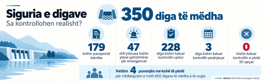
The auditors also found that only four employees were engaged full-time in the state supervision structures for about 650 large and small dams. In addition to the lack of capacity, the SAI found overlapping competencies in their control.
Downstream, the protection of lands and settlements depends on drainage canals, embankments and weirs. According to the Ministry of Agriculture, since 2016 almost all irrigation infrastructure and a significant part of the drainage infrastructure have been transferred to municipalities. The Ministry continues to administer a part of the main canals, 27 weirs and flood protection structures, through four regional directorates in Lezha, Durrës, Korça and Fier.
The Law on Irrigation and Drainage Administration defines the responsibilities of the ministry, directorates and municipalities for the infrastructure they administer. The question is whether this division works on the ground: whether the segments are clearly inventoried, maintained and connected to each other in a network that manages to remove water.
The ministry states that canals require cyclical cleaning, on average once every five years. According to its response, about 250-300 kilometers of main canals are cleaned each year and an average of 2,5-3 million m/³ of soil is removed. The institution also reports 2,3 billion lek investments in irrigation, drainage, hydropower and flood protection infrastructure for 2025, as well as 2,56 billion lek projected for 2026.
In the presentation of the 2026 draft budget, however, the ministry announced a ceiling of over 3,6 billion lek for irrigation, drainage and flood protection. The response provided does not clarify which items the 2,56 billion lek figure includes within this broader program.
Separately, the Ministry of Defense announced 4,3 billion lek foreseen for civil emergencies in 2026. This funding also includes capacities to cope with fires and other emergencies, so it cannot all be presented as a fund against floods.
From plans and controls to real protection
The National Civil Protection Agency told ACQJ that it conducts periodic inspections in municipalities and regions, updates the National Civil Emergency Plan, and works on early warning and monitoring of risk areas. AKMC says it coordinates interventions and supports local governments in damage assessment and rehabilitation.
But the European Commission's Albania 2025 report notes that response capacities are often overwhelmed, especially during wildfires, and calls for a review of plans, improvement of early warning infrastructure and strengthening of operational capacities. This assessment of the civil protection system as a whole also touches on flood preparedness.
In water management, the report found that five out of seven river basin plans were in implementation, while those for Shkumbini and Vjosa remained pending. Flood risk maps covered 96% of areas at significant risk, while maps of potential consequences covered 84% of areas at high risk.
The responses of the institutions also show fragmentation of the data. Municipalities report households and compensations, the Ministry of Agriculture interventions in the main network, AMBU plans and permits for the use of water resources, while the National Environment Agency (AKM) inspections near rivers. The information provided, however, does not create a common picture that links the state of a basin with the interventions, controls and damages recorded in it.
An example is the measures against activities near riverbeds. The KTA reports fines of one million lek each against the entities “ANCHOR Investments” and “Beton Express”, for activities near Erzen, as well as against “HEC Grabova 2”, for activities near Devoll. The institution also lists fines against “Vokopola Energji”, “Vëllezërit Hysa” and “GECI”, as well as warnings against “INC Spa” and “Infinert+”.
However, the response does not provide a complete overview of the specific violations, dates, complaints or execution of measures. For the subject “Vuthaj”, the KTA explains that the fine of 100 thousand lek was lifted by the complaints commission. Thus, the list of measures itself is not enough to understand which violations have been finally confirmed and whether they have been corrected.
On the other hand, the AMBU list for the permitted use of river aggregates contains nine items: Six in the Shkumbini basin, two in the Mati basin and one in the Vjosa basin. Some companies are repeated for different projects. According to the agency, these activities are permitted in cases specified for public road works.
The concentration of interventions in a basin raises the need to assess their combined impact. However, neither a permit nor a fine in itself proves the connection of the activity to a flood. This requires matching the location and timing of the intervention with the quantities of material extracted, bed changes and flow data. The responses received do not provide this analysis.
The second National Adaptation Plan 2026-2036, published by UNDP in January 2026, includes 66 priority measures and investment needs estimated at around $9,8 billion. The amount covers several sectors of climate change adaptation, not just flood protection.
Measures include the restoration of banks and the expansion of floodplains along major rivers, with a target of 300 kilometres of restoration and repair of embankments and protective works. But the accompanying financing strategy estimated that around 93% of the overall plan's needs remained unmet.
The causes and their severity vary from one flood to another. But some shortcomings are documented: canals that were not cleaned for years, incomplete damage data, delayed compensation, and weaknesses in dam supervision.
Institutional accountability can be measured by following the same event from beginning to end: What risk was identified, what intervention was funded, whether it was carried out, and what protection was provided. After the flood, the balance sheet should show the estimated damage, the funding approved, and the payment that reached the household or farmer.
For residents facing water in their homes and crops, the measure of success is concrete: less damage in the next flood and help arriving on time. That is where the value of the plans and the billions spent must be proven./ acqj.al